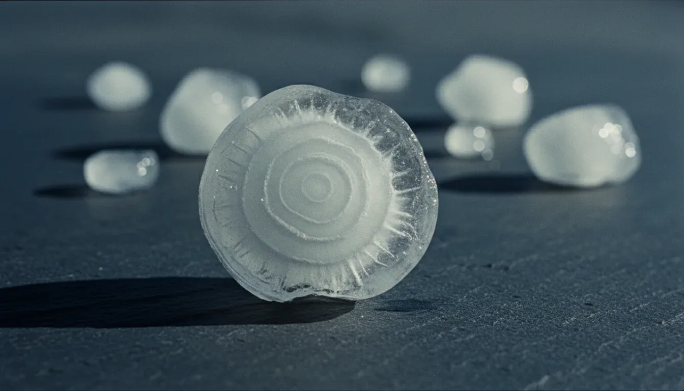
A hailstone is frozen weather you can hold. Every stone that lands in a yard was, not long before, miles above the roof it hit — riding one of the most violent elevators in nature, growing a layer at a time, until the storm could no longer carry the weight. This piece is about that machine: what builds a hailstone, why it falls where it falls, and why the cloud that flags the whole process gave our models their name.
The elevator inside the storm
Every thunderstorm is built around rising air — warm, moist air from near the ground accelerating upward through cooler air above it. In a strong storm that rising column, the updraft, stops being a gentle drift and becomes an organized engine: a sustained channel of air climbing at freeway speed, straight up.
High in that column, above the altitude where the air crosses freezing, something counterintuitive happens: the cloud's water does not freeze. Small, clean droplets can stay liquid well below the freezing point — meteorologists call the state supercooled — because freezing needs something to start on. Supercooled water is water waiting for an excuse.
A hail embryo is the excuse. It starts as a frozen droplet or a small pellet of soft ice, and once it exists, every supercooled droplet it collides with freezes onto it. The updraft holds the growing stone aloft in exactly the part of the cloud richest in supercooled water — a factory where the conveyor also happens to be the shelf. The stronger the updraft, the heavier the stone it can suspend, and the longer the stone stays in the growth region. That is the whole secret of giant hail: not colder storms, but stronger lift.
Read the rings
Cut a hailstone in half and it looks like a tree stump: concentric bands, some glassy and transparent, some milky white. Those two kinds of ice are the stone's growth regimes, and each band is a legible fact about where the stone was when it formed.
Clear ice · wet growth
The stone is collecting supercooled water faster than it can freeze it. A liquid film spreads across the surface and hardens slowly, letting trapped air escape. The result is glassy, transparent ice — the signature of a warmer, water-rich part of the storm.
Cloudy ice · dry growth
Droplets freeze the instant they hit, before they can spread, sealing countless tiny air bubbles into the ice. The result is white, opaque ice — the signature of a colder, drier part of the storm.
The cartoon version of hail formation has the stone yo-yoing up and down through the storm, one ring per lap. The real picture, from studies that trace simulated stones through modeled storms, is usually stranger: many large stones grow in a single sprawling pass — climbing, drifting sideways across the updraft, sampling different temperatures and water contents as they go. Each ring records a change in the stone's environment, not necessarily a round trip. Either way the conclusion holds: a hailstone is an autobiography, written in ice, by the storm itself.
Why it falls where it falls
A stone falls for one of two reasons: it grows too heavy for the updraft to hold, or the storm's own circulation carries it out of the strong lift and into air that cannot support it. Both endings are set by the same engine that did the growing — which is why the largest stones land close to the storm's core, while smaller ones ride the winds aloft further afield before coming down.
Then comes the descent, and the descent is a melt. A small stone falling through a warm summer afternoon may not survive to the ground at all — a great deal of would-be hail arrives as cold rain. A large stone has the opposite experience: it falls so fast that it spends almost no time in the warm air near the surface. That is why hail in July is not a contradiction, and why the stones that matter most are the ones least changed by the trip down.
| Common name | Across | On the ground |
|---|---|---|
| Pea | ¼ in | Often melts to cold rain before it lands |
| Quarter | 1 in | The conventional line where damage tallies begin |
| Golf ball | 1¾ in | Dents soft metal, bruises shingles |
| Tennis ball | 2½ in | Breaks windows, cracks roof decking |
| Softball | 4 in | Arrives nearly unmelted and hits like a thrown brick |
The cloud we named the models after
Follow the updraft all the way up and it eventually hits a ceiling: the stable layer that caps the weather. The rising air cannot punch much further, so it does the only thing left — it spreads sideways, smeared downwind into a vast, flat-topped sheet. From the ground, tens of miles away, that sheet reads as an anvil: the hard-edged, spreading crown that announces a mature storm to everyone under the horizon.
The anvil is not where hail forms. It is the exhaust — cloud material the updraft has already spent. But its shape is testimony: a storm wearing a crisp, sprawling anvil is a storm whose updraft reached the top of the weather with force to spare, and that is the same updraft that holds hailstones in the growth region below. The cloud is the visible flag of an updraft strong enough to make hail.
That is why the modeling platform behind Hail Sentinel is called Anvil, and why the post introducing it leads with a photograph of one. The models exist to watch for the machine this article describes; they carry the name of its signature.
Hail is a neighborhood event
Everything above happens inside a single storm cell, and the part of the cell that grows hail — the core — is small. Not county-sized. Neighborhood-sized. As the storm moves, that core paints a swath across the ground: a long, narrow strip of stones with edges sharp enough to split a street. Winds aloft sort the falling stones by size along the way, so the swath is graded too — the largest hail lands in a tighter band than the small stuff around it.
The result is weather that defies the way forecasts are usually spoken about. Two houses in the same town can have entirely different afternoons: softball stones through one roof, wet pavement at the other. A county-level statement about a cell-scale event is true for almost nobody in the county. This is the physical fact Hail Sentinel is shaped around — the forecast, the radar view, the alert, and the after-storm record are all read for one address at a time, because an address is the grain at which hail actually happens.
What radar sees, and what it can't
Radar is how anyone watches this machine at work. A radar sends out pulses of microwave energy and listens for the echo; precipitation scatters some of it back, and hail — large, dense, often wearing a film of meltwater — is among the loudest things a storm can put in the beam. Modern radars also transmit in two polarizations at once, which lets them tell something about shape: raindrops flatten as they fall, while tumbling hailstones look round on average. Seen this way, a storm with a hail factory running shows a recognizable anatomy — a dense core lofted high above the altitude where the air crosses freezing, held up by exactly the kind of updraft this article has been describing.
But notice what every part of that picture has in common: it is all aloft. A radar beam leaves its antenna and climbs as it travels, so at a distance it passes far above the rooftops it is meant to serve. Radar watches the engine — the lofted core, the spin of the inflow, the strength of the echo — and from the engine it infers the street. It does not watch the stone land. The melt on the way down, the sharp edge of the swath, the drift between the scanned altitude and the ground: all of that happens below the beam.
So the honest summary of the science is this: the sky writes the story of a hailstorm twice. Once in the air, where radar can read it — and once on the ground, where the record is still written the old way, by people who stood under the storm and wrote down what fell. How complete that second record is, and what its gaps do to every accuracy number this industry publishes, is a story of its own — and it is where we are headed next.